
Chris Glaisek seizes the long silver pump handle with his left hand and presses down. As he works the lever, water gushes from a short spout onto a narrow wooden table with raised sides and slots cut at both ends. “I think this is one of the tables that you tilt,” he says, touching one side as a test. “Yeah. So you can decide which way you want the water to run.” The water pours off, wetting the rough, pale red pavement at Glaisek’s feet, then trickles downslope into the first of a series of shallow, hand-sculpted concrete bowls tinted the same pale red in Toronto’s Biidaasige Park.
With Toronto under its latest heat warning and the sun climbing in the morning sky, a little fun during working hours in the city’s newest water-play area — 1,600 square metres of undulating concrete, stone, sand and spray dubbed “the Badlands Scramble” — seems entirely appropriate, even for someone whose Waterfront Toronto business card reads “chief planning and design officer.”
But this is no diversion. Glaisek is just an enthusiastic tour guide. Ten days prior, on July 18, Waterfront Toronto — the partnership between the City, the province of Ontario and the federal government that oversees revitalization of the city’s Lake Ontario waterfront — officially opened the first 20-hectare phase of the all-new Biidaasige Park in the Port Lands industrial district. There, the Scramble is one of several signature elements in a larger, centrally located playground that also features a fantastic owl-shaped amphitheatre and ziplines. Beyond that, there are picnic and grill areas, several kilometres of walking trails, separated bike paths, outlooks, canoe and kayak launches, and more activities, event spaces and art installations are planned. Those I spoke to who were involved in the project, which formally started when U.S.-based landscape architects Michael Van Valkenburgh Associates (MVVA) won a public design competition in 2007, are still on a high.

They’re thrilled with the park (which will grow by another six or seven hectares in two stages in 2026 and 2028), with the big public turnout and with the early positive reception. But the inauguration of the first phase also heralds something more: the successful completion of the $1.4 billion Port Lands Flood Protection (PLFP) project, a remarkable, one-of-a-kind (indeed, once-in-a-generation) undertaking that saw MVVA lead the creation of a fully naturalized 1.3-kilometre river channel in what was formerly an industrial wasteland — from scratch.
That new river valley, already lush with native aquatic, wetland and forest plantings and teeming with fish, birds and other wildlife, is an extension of the Don River, which originates north of the city. In Toronto’s early years, its deep valley was home to mills and brickworks. For millennia prior, it was one of several rivers in the area that Indigenous peoples used for travel into the interior. In the early 1900s, however, the mouth of the Don was diverted, forced to make a 90-degree right turn at the old shoreline and enter the lake through a walled passage called the Keating Channel. This allowed the city to fill in the marsh that the river used to spill into to create new land for development.

Rivers don’t make 90-degree turns naturally, however. And as the watershed urbanized, more intense runoff during heavier rainstorms led to more frequent flooding as the channel backed up. But now, the new river and another spillover corridor called the Don Greenway have solved that problem. Together, they have capacity to ensure that even in a hurricane-scale rainfall event, water coming down the river will get to the lake without inundating the surroundings.
Not only does this mitigate climate change–exacerbated damage and disruption, but it opens up more than 170 hectares of adjacent lands in and around the Port Lands for redevelopment. That flood protection and potential for neighbourhood revitalization, enhanced by the proximity of a dynamic nature-centric park in view of downtown, were the economic rationale for the PLFP’s $1.4 billion price tag.
“That was the design competition’s goal: How can this river naturalization project enhance real estate values down here, actually attract development and attract people to want to live here?” says Glaisek. High-quality public space and urban benefits were to be key parts of that solution. “The design brief said to build a park system along with [the flood protection and the new river] that will serve the community and also be a regional benefit. Without [that], it wouldn’t have had the same catalytic impact that it’s going to have now.”

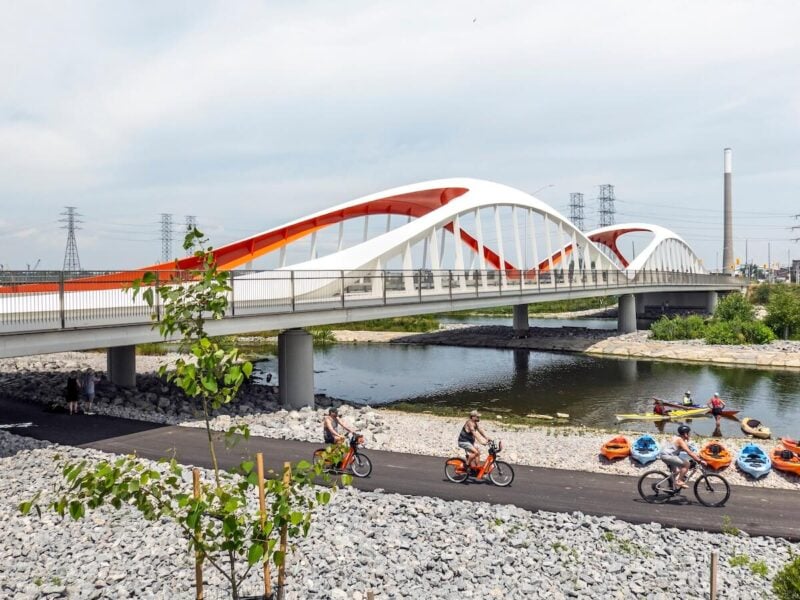
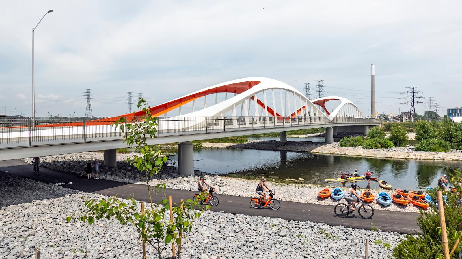
After that starting point came a decade of planning and seven years of construction that tested MVVA’s abilities. In all, it had more than 20 consulting firms — ecologists, hydrologists, environmental engineers — on its team. Their work included extensive flood modelling as well as moving roads and a historic fire hall, installing new bridges (vibrant and voluptuous ones designed by U.K. firm Grimshaw), and excavating and remediating 1.4 million cubic metres of soil, much of it contaminated during decades of occupation by refineries, marine terminals and other industry. They built the new channel from the bedrock up, encircling it with multiple environmental barriers, including, in many areas, a water-tight secant wall. Once the heavy engineering was done, they started planting: more than 5,000 trees, 77,000 shrubs and two million herbaceous plants as of early this year. Removal of the last “plugs” in the channel to allow the river to run freely took place in November.
“We’ve kind of been building up to this project, quite honestly,” says Boston-based Laura Solano, an MVVA partner and PLFP project manager. That’s quite a statement coming from a firm that is internationally renowned for creating large-scale urban parks that rehabilitate and reconnect inner-city locales with their rivers and waterfronts, including Brooklyn Bridge Park in New York City, the CityArchRiver project in St. Louis and Maggie Daley Park in Chicago. But it speaks to the challenge and complexity of what it had to deliver. “We’ve had the individual pieces of this park in different projects over the years,” says Solano, “[but] this is a project that brought all of our experience to bear.”


Once Glaisek ends his tour, I take a trail along the south bank of the river to the park’s eastern edge. Up the channel from there, I can see a line of red buoys where the new river starts, the same point Keating Channel cuts into the old Don River from the west.
The new river runs south for a few hundred metres, then also bends west — but in this case, tracing a long, lazy S-curve before straightening again at the Inner Harbour. Fittingly, Biidaasige Park straddles its entire length. With a couple of exceptions, wherever you stand, you’re never more than 100 metres from either the river proper or one of three “embayments” — narrow wetland lagoons separated from the river by thin levees except where they open at the downstream end.
Interestingly, both that S-curve and the embayments were added to the design following visits by the MVVA team to the nearby Rouge, Duffins
and Humber Rivers. What they saw at these “river mouth analogue sites” was a “revelation that changed the design altogether,” says Herb Sweeney, an MVVA principal and the project’s team captain. Rather than taking a “super-speedway” approach with the new channel, Sweeney says, they realized they could just as effectively convey the flood waters over the levees and through the wetlands, which allowed them to widen the latter and increase their habitat value. Reconfiguring the design also freed up space for other features.
In its final form, apart from the actual river, the park now consists of two landscapes: floodplain and uplands. Because the former is a potential flood zone, it has no buildings or pavement. Glaisek describes it as “a rugged, naturalized” landscape with flood-resilient vegetation and riverbank engineering, where nature is the focus and the primary activities are walking, kayaking and canoeing, birdwatching and fishing. If there is a flood, it can be quickly cleaned up and made accessible again.

The uplands above the maximum flood line, meanwhile, are where MVVA situated the playground and picnic areas, washrooms and other public infrastructure (some not yet built), the fire hall (opening as a recreation centre in 2026), bike trails, off-leash dog zones, and most of the larger tree species and related plant communities — the beginnings of an “upland forest in the park” with a root system that assists in anchoring the edges of the river banks, protecting them from erosion. There’s more to come, too, in the unfinished section at the west end of the channel that will open next year: an event lawn, a water’s-edge promenade along the harbour, a one-acre Canoe Cove (dedicated to novice paddlers and with rentable canoes) and a restored 300-ton Atlas Crane, a landmark that nods to the area’s industrial past.
Of the few places in the park where the river is slightly more distant, only one is complete. That’s the Don Greenway, the overflow spillway in the southeast corner of the park. (The others are in the northwest corner, which won’t be finished until 2028.) The Greenway extends south from the bend in the new river until it meets the lake at a shipping channel that parallels the park. In that space, a walkway rings a large wetland that’s fed only by the lake. At its centre is a small island that’s off-limits to people. With dragonflies darting over the water and red-winged blackbirds chattering in the trees, it is possibly the quietest, most contemplative urban nature-bathing setting in the entire place.
As Biidaasige Park continues to expand and take shape between now and next year, a pair of interrelated elements will be present in both the floodplain and upland landscapes. The first is the Lassonde Art Trail. Created in conjunction with MVVA and launched with a $25 million gift from philanthropist Pierre Lassonde, it will feature a mixture of permanent and temporary art exhibits at up to 15 sites along the main pathway system. The current plan, according to Lassonde’s executive director Chloë Catán, who has been working with MVVA on a public art strategy for several years, is to open the trail next June with two permanent installations and up to six temporary pieces.
The first of those permanent pieces, called Trajet, has already been installed. A flat bronze disc anchored close to the river in the park’s eastern end, it features a cast of footprints, commemorating actual footprints left by Indigenous ancestors that were found in clay on the floor of Lake Ontario during a construction project in 1908. Lassonde also recently announced that its second permanent installation will be the first public piece ever created by Cree painter Kent Monkman.

Besides this art, Indigenous input, influences and design elements run deeply through the Biidaasige Park project. An important early step in this process was the signing of a memorandum of understanding by Waterfront Toronto and the Mississaugas of the Credit First Nation in 2020. In collaboration with consultants MinoKamik Collective, an Indigenous consultancy led by elder Shelley Charles from the Chippewas of Georgina Island First Nation, and with the Mississaugas of the Credit First Nation, the design team met with Indigenous people in and around Toronto in the early planning phase, who expressed a wish to highlight local Anishinaabe traditions, stories and culture. Dodem animal sculptures representing seven Anishinaabe clans are already installed around the playground, and future plans include construction of a shade structure, a ceremonial fire holder, sturgeon stones, marker trees and other elements.
Charles also collaborated with MVVA to develop an Indigenous planting palette for the site. And she convened an Indigenous advisory circle that, last year, selected the names for both Biidaasige Park (which means “sunlight shining toward us” in Anishinaabemowin/Ojibwemowin) as well as the new island — Ookwemin Minising (“place of the black cherry trees”) — that came into being when MVVA’s new channel was completed, encircling the land between it and the Keating Channel. Ookwemin Minising is being developed into a much-anticipated residential hub that will house some 15,000 people; its realization into that “place where people want to live,” as Glaisek called it, will bring the Port Lands revitalization full circle.
The entire consultative process was “fantastic,” says Sweeney. “The resounding feedback that we had, when we were just going in and exploring what those groups were looking to see happen with this place, was fundamentally what the project was looking to do: re-engage the land, bringing it back, bringing the water back to where it wants to flow out of Lake Ontario [and] reintroducing the plantings that were there pre-settlement.” Now, with the park newly opened, the initial reaction has echoed many of those same desires. “The feedback that I heard from people walking around [was] about the birds and the frogs and the fish that were being seen.” Sweeney says it’s been “rewarding” to hear people get so excited about things like that, rather than focusing only on the formal elements in the uplands. “It was about the river. And that was really, really great.”
Everyone Say Biidaasige: Toronto’s Marvellous Park Is Just the Beginning for a New Port Lands
The crowning jewel in a $1.4 billion revitalization, Biidaasige Park stretches along the Don River’s mouth, which has been rerouted to open up Toronto’s previously flood-prone Port Lands for residential development. A once-in-a generation undertaking, the resplendent green space is already in full use — by hikers, cyclists, kayakers and playground scramblers.